This story is no longer being updated. Get the latest forecast track here.
TAMPA, Fla. (WFLA) – A Tropical Storm Warning has been issued for much of Florida’s west coast, including the Tampa Bay area, as Tropical Storm Eta starts moving north away from Cuba. Meanwhile, the National Hurricane Center is also keeping an eye on a subtropical storm in the eastern Atlantic Ocean and a tropical wave over the Caribbean Sea.
Tropical Storm Eta
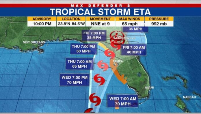
Eta’s eastward shift in the forecast models has not been a good one for Tampa Bay. The center of Tropical Storm Eta may pass off to our west but this lopsided system will likely bring tropical storm conditions to Tampa Bay late Wednesday into Thursday.
A Tropical Storm Warning is now in effect for coastal areas. A Flash Flood Watch and Storm Surge Watch are also in effect. Expect periods of heavy rain and wind gusts up to around 50 MPH with stronger gusts at the coast possible. Higher than normal tides are expected with a potential peak storm surge of 2-4 feet per the National Hurricane Center.
As of 10 p.m. ET, Eta is about 315 miles south-southwest of Tampa. Maximum sustained winds are 65 mph.
Eta spent most of the day Tuesday stationary off the coast of Cuba but the NHC said at 11 p.m. it was moving north at about 9 mph. The storm is expected to continue north or northeast through Wednesday night. It’s then forecast to turn toward the northeast Thursday.
The latest advisory from the NHC brought a Tropical Storm Warning and Storm Surge Watch for the entire coast of West-Central and Southwest Florida.
A Tropical Storm Warning is in effect for:
- The Dry Tortugas
- Bonita Beach to Suwannee River
A Tropical Storm Watch is in effect for:
- North of the Suwannee River to Aucilla River Florida
- The Cuban provinces of La Habana, Artemisa, Mayabeque, Pinar del Rio and the Isle of Youth
A Tropical Storm Warning means tropical storm conditions are possible within about 36 hours.
Eta could dump an additional 1 to 5 inches of rain on portions of South Florida and western Cuba on Tuesday, with some areas seeing isolated amounts of 20 to 25 inches.
Tropical Storm Eta brought major flooding to South Florida after making landfall in the Florida Keys late Sunday night. With outer rainbands extending outward up to 310 miles from its center, Eta soaked much of South Florida Monday, including the Tampa Bay area, and caused flash flooding in cities like Miami and Fort Lauderdale.
Subtropical Storm Theta
Subtropical Storm Theta formed over the northeastern Atlantic on Monday night.
Theta is the 29th named storm of the 2020 Atlantic hurricane, breaking the previous record of 28 named storms that was set in 2005.
The NHC said the system is about 860 miles southwest of the Azores with 70 mph maximum sustained winds. Theta is expected to stay over the eastern Atlantic over the next few days.
Tropical wave
A tropical wave is producing disorganized showers and thunderstorms over the eastern Caribbean Sea, according to the NHC. The wave is forecast to move west into more conducive environment conditions in the coming days.
A tropical depression is likely to form later this week or this weekend as the wave reaches the central or western Caribbean Sea. The NHC has given the wave a high 70 percent chance of formation through the next five days.


