


Tropical storm Sally is strengthening, prompting hurricane and storm surge warnings for parts of the northern Gulf Coast.
A hurricane warning for Sally was issued Sunday morning from Grand Isle, La., to Ocean Springs, Miss., and included metropolitan New Orleans. A storm surge warning and a tropical storm warning also were in effect for parts of the Gulf Coast.
“Life threatening storm surge is possible along the Gulf Coast beginning on Monday, and a Storm Surge watch is in effect for areas outside the southeast Louisiana Hurricane and Storm Damage Risk Reduction System from the Mouth of the Mississippi River to the Alabama/Florida border,” the National Weather Service said in a statement released Saturday.
HURRICANE SEASON PEAK: HERE’S WHY SEPT. 10 IS DAY MOST LIKELY TO HAVE A TROPICAL STORM
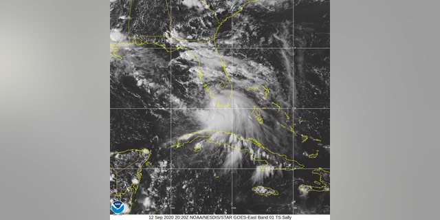
This Saturday, Sept. 12, 2020 image provided by NOAA shows the formation of Tropical Storm Sally. Tropical Storm Sally has formed off south Florida, becoming the earliest 18th-named tropical storm on record in a busy Atlantic hurricane season.
(NOAA via AP)
On Saturday Louisiana Gov. John Bel Edwards also declared a state of emergency in advance of tropical storm Sally.
“Make sure that you do what is necessary to prepare for Tropical Storm #Sally,” he tweeted Sunday.
Officials in the New Orleans area issued a mandatory evacuation order for areas outside of levee protection.
TIPS FOR USING A GENERATOR SAFELY DURING A HURRICANE
The storm was about 115 miles west of Port Charlotte, Fla., and 345 miles east-southeast of the mouth of the Mississippi River, according to an advisory issued by the National Hurricane Center at 5:00 a.m. ET Sunday. “Air Force Reserve Hurricane Hunter aircraft indicate that maximum sustained winds have increased to near 50 mph (85 km/h) with higher gusts,” it said. “Tropical-storm-force winds extend outward up to 90 miles (150 km) from the center.”
“Sally is moving toward the west-northwest near 13 mph (20 km/h), and a west-northwestward or northwestward motion is expected through Monday,” the National Hurricane Center explained.
Storm surge from Sally was forecast to reach dangerous levels, due in part to the tide. Up to 11 feet of water was predicted from the mouth of the Mississippi River to Ocean Springs, Miss., including Lake Borgne.
Other weather systems are also being closely monitored. Hurricane Paulette is moving closer to Bermuda, the National Hurricane Center said early Sunday while tropical depression Rene, which was once a tropical storm, will become a remnant low on Monday.
CLICK HERE TO GET THE FOX NEWS APP
Tropical Depression Twenty is expected to gradually strengthen over the next several days.
The Associated Press contributed to this article.
Follow James Rogers on Twitter @jamesjrogers


